In this
webquest, you and three other junior scientists will need to create a tri-fold
brochure by researching, describing, identifying, and explaining five different
formations across Texas, such as a mountain, hill, valley, plain, volcano, or
beach.
Webquest Roles and Rubrics:
|
With a group of 4, each of you will pick one of the 4 tasks to complete:
|
1. Field Researcher: Name and definition of each landform. You will have 5 pages and 5 landforms.
2. Geographer: Tell where each of the landform are located. 3. Cartographer: Draw pictures showing the steps in the formation of a landform, such as a mountain, hill, valley, or plain. 4. Geologist: Describe the forces or processes that create that type of landform. |
|
Key evaluation concepts.
|
1. A landform is a natural geographic structure on the Earth's surface.
2. Landforms, including mountains, hills, valleys, and plains, have specific characteristics. 3. Landforms can look very different but can be formed by similar processes. 4. We can compare different landforms based on their characteristics. |
|
Individual Checklist/Rubric
1. Did you select 5 landforms to illustrate? (20 pts) 2. Did you tell where your landforms where located in Texas? (20 pts) 3. Did you create a cover for your brochure? (5 pts) 4. Do your illustrations describe how the landform was created? (20 pts) 5. Did you describe the forces or processes that formed your landform? (20 pts) 6. Did you share your brochure with a classmate? (10 pts) |
Yes or No
1. 2. 3. 4. 5. 6. |
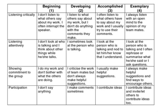
Group Rubric
Each group member will need to download and score themselves.
Each group member will need to download and score themselves.
